


Northeast Pacific Hurricane History
The Northeast Pacific basin ranks as the second most active tropical cyclone nursery on Earth, averaging roughly 15 named storms, 8 hurricanes, and 4 major hurricanes each season. Historical satellite records document hundreds of tropical systems traversing these waters, spanning all categories of the Saffir-Simpson Hurricane Wind Scale. Category 1 and Category 2 storms make up the bulk of operational systems, while Category 3 through Category 5 major hurricanes represent the most dangerous, high-impact events.
Historical activity fluctuates widely from year to year. Hyperactive seasons like 1992 (27 tropical storms and 16 hurricanes) and the landmark El Niño season of 2015 (26 tropical storms, 16 hurricanes, and 11 major hurricanes) proved how energetic the basin can become. Conversely, quiet seasons like 1977 and 2010 saw suppressed activity, with 2010 generating only 8 total named storms and 3 hurricanes.
Catastrophic Milestones & Recent Disruptions Across Baja
The storms that left the deepest marks on the Baja California peninsula and western Mexico combined high moisture transport, rapid strengthening, and vulnerable infrastructure:
Hurricane Liza (1976)
Striking near La Paz as a Category 4 hurricane, Liza remains the deadliest natural disaster in peninsular history. Torrential rains caused the catastrophic failure of the earthen El Cajoncito dam, sending a massive wall of water and debris sweeping down populated arroyos, claiming between 1,200 and 2,000 lives.
 Neighborhood in La Paz, BCS torn apart by Hurricane Liza (1976)
Hurricane Pauline (1997)
Carving a destructive path along the southern coast of Mexico during a strong El Niño year, Pauline dropped unprecedented rainfall across the coastal mountains. The resulting landslides and flash floods in Oaxaca and Guerrero took hundreds of lives and flattened regional infrastructure.
Hurricane John (2006)
Making landfall near Cabo del Este as a Category 2 hurricane, John tracked directly along the peninsular spine. The overflowing of the Iguagil Dam in Comondú submerged vast agricultural lowlands, isolating 15 rural communities under deep floodwaters and severing access across Baja California Sur.
Hurricane Norbert (2008)
Norbert crossed the peninsula twice, striking Puerto San Carlos as a Category 2 hurricane before moving across the landmass, entering the Gulf of California, and making a second landfall in Sonora. Norbert tore off roofs, knocked out communication towers, and heavily damaged fishing camps throughout Magdalena Bay.
Hurricane Jimena (2009)
Peaking offshore as an intense Category 4 hurricane before crawling ashore near Puerto San Carlos and Santa Rosalía, Jimena delivered prolonged, slow-motion destruction. Up to 20 inches of rainfall inundated Mulegé, putting the downtown bridge under six feet of water, ripping through Santa Rosalía with violent canyon washouts, leveling half the processing facilities in Puerto Adolfo López Mateos, and severing basic supply chains across Comondú and Loreto.
Hurricane Paul (2012)
Approaching as a major Category 3 hurricane before striking near Puerto San Carlos as a Category 1, Paul knocked out communications and downed power grids across La Paz and Los Cabos. Its primary impact was heavy rainfall across the Comondú agricultural belt, blowing out low-water road crossings, stranding local transport, and destroying seasonal crops.
 Aftermath of Hurricane Odile 2014
Hurricane Odile (2014)
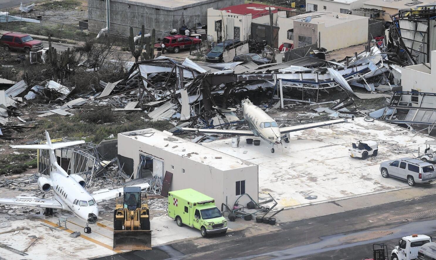
Odile struck near Cabo San Lucas as a high-end Category 3 hurricane (after peaking offshore at Category 4), becoming the costliest natural disaster in Baja California Sur history. Extreme winds exceeding 125 mph and storm surge collapsed steel electrical transmission towers, shattered resort infrastructure, flattened neighborhoods, and caused over $1.8 billion in destruction.
Hurricane Kay (2022)
Sweeping along the Pacific shelf as a large Category 1–2 system before making landfall as a tropical storm near Bahía Asunción, Kay paralyzed the peninsula through sheer spatial coverage. Rainfall exceeding 15 inches across the central mountain spine washed out multiple sections of Highway 1, isolating communities from San Ignacio and Santa Rosalía up to Cataviña and San Quintín while severing supply lines for days.
Hurricane Hilary (2023)
Peaking as a Category 4 hurricane offshore before tracking up the Pacific coastline and making landfall near San Quintín as a tropical storm, Hilary proved that tropical systems can carry tropical-storm-force wind gusts and heavy moisture straight across the Northern Baja Pacific and into Southern California. Its outer bands tore out chunks of Highway 1, flooded desert crossings around Cataviña, cut power to over 300,000 customers across Mexico, and shut down coastal ports.
 Damaged Homes from Hurricane Hilary 2023
Hurricane Otis (2023)
Several hundred miles south of Cabo San Lucas, Otis set a global benchmark for explosive intensification back in 2023, jumping by 115 mph in under 24 hours from an unassuming tropical storm into a 165 mph Category 5 monster right before slamming directly into Acapulco. Otis demonstrated the extreme danger created when a tropical cyclone taps deep, uninterrupted nearshore ocean heat.
What causes Hurricanes?
Critical Ingredients & The Power of Ocean Temperatures
A tropical cyclone functions as a massive thermodynamic heat engine. To develop and maintain its strength, it requires light vertical wind shear (a sudden change in wind speed, wind direction, or both over a short distance in the atmosphere), rich mid-level atmospheric moisture, a pre-existing low-pressure disturbance, and very warm ocean water.
Among this list of factors, ocean water temperature serves as the core fuel supply.
Hurricanes draw thermal energy directly from the ocean surface. When warm seawater evaporates into the lower atmosphere, it rises into the storm’s core, condenses into towering thunderstorm clouds, and releases immense latent heat. This heat release lowers central atmospheric pressure, accelerating surface winds that pull even more moisture from the sea in a self-reinforcing loop.
The recognized baseline to support tropical storm formation is about 80°F (26.5°C ). However, when water temperatures climb into the mid-to-upper 80s, the potential intensity ceiling escalates rapidly:
Hurricane Liza (1976): Fueled by ocean temperatures hovering between 85°F and 87°F at the mouth of the Gulf of California.
Hurricane Odile (2014): Tapped an expansive pool of 86°F to 88°F water off southwest Mexico and Baja California Sur, preventing the storm from weakening before its Cape landfall.
Hurricane Otis (2023): Fed on a concentrated marine heatwave where nearshore waters reached 88°F to 89°F, providing the thermal fuel needed for its rapid intensification.
The 2026 NE Pacific Shift
From ENSO-Neutral to a Supercharged El Niño in 60 Days
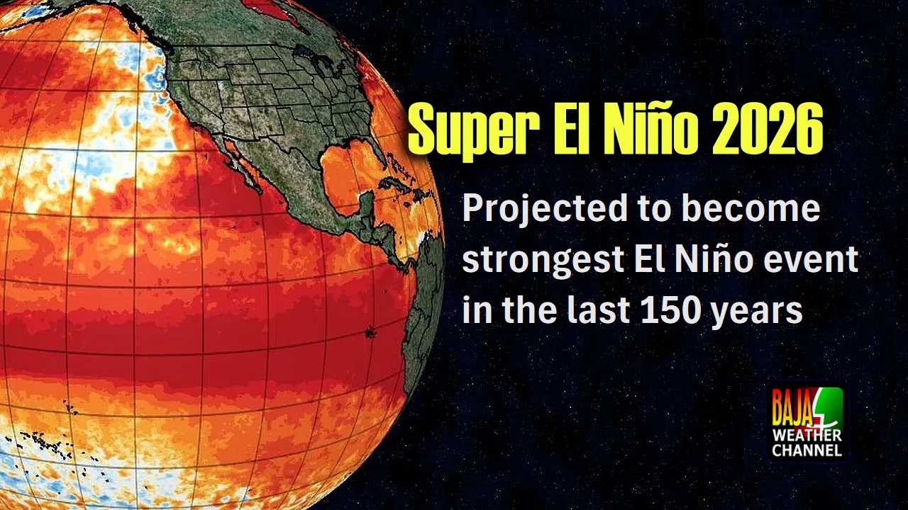
Earlier this year, long-range climate outlooks pointed toward ENSO-neutral conditions across the Pacific. Over the late spring and early summer, equatorial sea surface temperatures began a rapid, steady climb, shifting the forecast past weak El Niño thresholds into an energetic, supercharged Pacific pattern.
Across our coastal waters, Southern Baja, and the Gulf of California, SST (sea surface temperature) measurements have been running well above normal since early June. For over two months, unbroken summer sun and strong atmospheric high pressure have continuously baked the ocean surface.
This sustained heating creates a major thermodynamic hazard: Ocean Heat Content (OHC).
This heat is not just resting in the top few inches of water; weeks of solar radiation and wind mixing have driven warm water deep into the column, pushing the vital 79°F boundary down 150 to 250 feet.
Under normal summer conditions, when a hurricane slows down or stalls, its powerful cyclonic winds churn up cold water from the depths—a natural braking process called upwelling that cools the sea and chokes the storm. With deep thermal storage in place, upwelling simply recirculates 82°F to 85°F water back into the core, disabling the ocean’s natural brakes and allowing slow-moving systems to maintain or even increase their strength.

A Fortunate Season So Far & The Warning of Tropical Storm Lala
Through the first half of this season, the Baja California peninsula has remained fortunate. While the eastern Pacific has generated active tropical waves, dominant high-pressure ridges have kept systems tracking safely out into open water.
However, the recent behavior of Tropical Storm Lala in the Central Pacific provides a clear example of the hazards associated with non-landfalling systems. Lala remained entirely offshore, passing south of the main Hawaiian Islands. Furthermore, it moved over ocean temperatures running between 81°F and 82°F—warm enough to sustain a tropical storm, but relatively cool compared to our local waters around the peninsula.
Despite staying offshore as a moderate tropical storm, Lala’s deep outer moisture bands dropped upwards of 35 inches of torrential rain across mountain slopes. The resulting flash floods washed out highways, tore more than 100 structures from their foundations, and cut power to over 180,000 residents across the islands.
Baja Reality Check
An Unprecedented Thermal Pool Surrounds the Peninsula
The widespread damage caused by Tropical Storm Lala over 81°F water highlights the potentially dangerous conditions right here in our own backyard currently.
SSTs offshore the Southern Baja Pacific coastline are holding between 84°F and 87°F, while the entire Gulf of California has heated into an expansive thermal pool running between 88°F and 91°F. The SST measured just offshore Cabo San Lucas recorded 90°F this morning.
These numbers represent deep atmospheric fuel.
If an organized tropical wave turns toward the southern tip of Baja or enters the Gulf of California during the coming weeks, it will not encounter marginal water—it will tap an ocean heat reservoir capable of supporting rapid intensification, elevated storm surge, and massive moisture transport.
A developing area of low pressure offshore Southern Mexico has caught our attention over the weekend as a few of the extended models are predicting for this system to develop into a strong tropical cyclone, currently forecast to track in the general direction of the Baja Peninsula.
To clarify – this is preliminary data and only the GFS & GEFS Ensembles currently project the Baja Peninsula track. The ECMWF model is currently projecting for somewhat slower development of this system with a projected WNW track that would keep the system well southwest of Cabo San Lucas. Other Ensemble models suggest an even more westerly track right now.
We should have a better idea for potential tracking later this week as the area of low pressure continues to organize and begin to spin, which should bring the models into better agreement and give us better information as to what we can expect.
What is clear however, is that community hurricane preparedness across Southern Baja is essential right now!

Hurricane Prep for Baja Mexico
Preparing for a tropical weather system across the Baja California peninsula requires a realistic understanding of local terrain, utility dependencies, and infrastructure bottlenecks. Because the Transpeninsular (Highway 1) can wash out quickly and municipal power grids or water distribution systems often take days to recover, self-reliance is vital.
Taking action now—while skies are clear and store shelves are fully stocked—ensures you are not caught in a last-minute scramble when a hurricane warning is announced.
Universal Essentials Checklist
Ensure every household and travel group maintains immediate access to these core supplies:
Drinking & Sanitation Water in Extra Containers: Maintain a minimum of one gallon of potable water per person per day for at least 7 to 10 days. Keep multiple extra 5-gallon containers (garrafones and buckets) on hand to purchase drinking water and haul wash water, as water distribution is frequently rationed during post-storm recovery.
Non-Perishable Food: Stock shelf-stable items that require zero refrigeration and minimal cooking, such as canned meats, tuna, beans, dried fruit, nuts, energy bars, and a reliable manual can opener.
Emergency Power, Backup Solar & Small Generators: Consider purchasing a small, quiet inverter generator to keep essentials running. Many residents across the peninsula utilize a simple backup solar kit—a few solar panels paired with four deep-cycle batteries wired to an inverter—which easily powers a small refrigerator, a single-burner hot plate and an internet router or Starlink terminal to maintain vital communications.
Cooking: An LPG camping stove is handy to have in the event that your kitchen stove is not available due to loss of power, property damage or whatever other reason. Also, you can normally expect for very hot weather after the storm passes and with no A/C, cooking outdoors helps keep your house a bit cooler.
Spare Fuel & LP Gas: Store extra 5-gallon fuel cans filled with stabilized gasoline for generators and vehicles. Keep at least one full spare LPG cylinder (tanque de gas) on hand for cooking on outdoor camp stoves or hot plates.
Mexican Pesos Cash Reserves: Keep a good supply of cash on hand in Mexican Pesos with a moderate amount of that cash in smaller denominations ($20, $50, $100 and $200 pesos). When the electrical grid collapses, ATMs are unavailable and local neighborhood tienditas and fuel stops often prefer or may even require pesos over US dollars.
Pet Care & Safety Space: Plan ahead for your domestic pets. Stock extra dry and canned pet food, dedicated pet drinking water, and necessary medications. Identify a secure, dry indoor area or elevated, covered kennel space where pets can safely ride out extreme wind and rising floodwaters if they cannot be kept in the main living quarters.
Medical Supplies & Prescriptions: A well-stocked first aid kit, pain relievers, antiseptic wipes, insect repellent, rehydration salts, and at least a 30-day reserve of essential daily prescription medications.
Important Documents: Store passports, resident cards, vehicle titles, property deeds, and Mexican auto/home insurance policies inside heavy-duty waterproof bags.
Emergency Radio & Shelter Coordination: Check with your local delegation or municipal Protección Civil office in advance to confirm where neighborhood temporary emergency shelters (albergues) are located. Find out if local civil protection, fire, or community rescue groups will be monitoring specific VHF or UHF radio frequencies during a disaster, and keep a battery-powered radio or handheld transceiver programmed and ready.

Special Considerations
Permanent Residents & Property Owners
Structural Protection: Inspect hurricane shutters or pre-cut 5/8-inch plywood coverings for all large windows and sliding glass doors. Ensure mounting hardware is clean, lubricated, and ready for immediate deployment.
Yard & Rooftop Cleanup: Clear tinacos (rooftop water tanks), solar water heaters, and satellite dishes. Tie down or move indoor patio furniture, loose propane tanks, trash bins, potted plants, and shade sails that could transform into dangerous wind-borne projectiles.
Drainage & Arroyo Flow: Clear nearby property culverts, drains, and roof gutters of sand and debris. If your home sits near an active arroyo or historical flood channel, install sandbags early.
Water Cisterns & Pumping: Fill all underground cisterns (pilas) to maximum capacity and verify that backup transfer pumps, generator lines, and fuel storage cans are operational.
Travelers, Tourists & RV Campers
Monitor Local Updates: Do not rely on casual conversation. Follow official Civil Protection (Protección Civil) advisories and community updates on Talk Baja for storm tracking.
Vehicle Preparation: Keep your fuel tank full as much as possible. Gas stations usually cannot pump gasoline during grid outages, and delivery tanker trucks will be halted if highway washouts occur.
Avoid Flood Zones & Arroyos: Never camp, park, or attempt to sleep in an RV inside dry riverbeds, low-lying coastal estuaries, or beach flats during an approaching storm. What looks like a dry ditch can turn into a violent, impassable wall of mud and water in minutes.
Evacuation Routes: Identify higher-ground shelter alternatives and solid concrete hotel structures well before wind and rain arrive. If local authorities advise evacuation for your coastal sector, move inland immediately.
Remote & Off-Grid Living (Ranchos, Fishing Camps & Desert Outposts)
Extended Self-Sufficiency: Assume complete physical isolation for 10 to 14 days. Municipal emergency services, military relief squadrons and utility repair crews cannot navigate remote desert tracks or washed-out dirt roads immediately following a storm and they usually focus on more populated areas that suffered the most damage first.
Satellite & Off-Grid Communication: Maintain a backup satellite communicator (such as a Garmin inReach or satellite messenger) or VHF two-way radio with charged auxiliary power packs to broadcast emergency coordinates if traditional communication towers fail.
Solar & Generator Safeguards: Protect solar panel arrays from flying gravel and severe wind shear. Store backup generators in elevated, dry enclosures and secure sufficient stabilized fuel to run critical refrigeration and water pumps during extended recovery periods.
Emergency Access Roads: Inspect private rancho roads, creek crossings, and trail gates in advance. Park your primary 4WD vehicle on the high side of any potential drainage washout so you are not trapped if an arroyo cuts through your driveway.

Stay Informed
Tropical weather conditions can and often do evolve with extreme speed across the Eastern Pacific. A subtle shift in steering currents or an unexpected burst of rapid intensification can significantly alter a storm’s track, forward speed, peak wind speeds, and localized rainfall totals in a matter of hours.
To stay ahead of changing conditions and monitor real-time reports of structural damage, flash flooding, arroyo washouts, mudslides, highway and road closures as well as the latest information on power outages / restoration as well as emergency and government aid responses, stay tuned across our dedicated community channels:
Baja Weather Channel on Facebook – Dedicated regional weather alerts, satellite analysis, sea surface temperature tracking, and meteorological forecasts covering the entire Baja California peninsula.
Baja Storm Chat – Live Updates – Our real-time community monitoring hub where local residents, storm spotters, and civil protection contacts share live conditions, eyewall impacts, rainfall totals and neighborhood updates during active storm events.
Talk Baja Road Conditions – The primary peninsular resource for live, crowd-sourced highway reports, arroyo crossings, mudslide alerts, bridge washouts, and detour notices along major Highways and access roads as well as secondary routes.
Talk Baja – The main group for Baja’s largest online community network, providing comprehensive situational updates, emergency shelter coordination, local relief efforts and broad peninsular support before, during, and after major storms.



Responses